 geo.be Metadata Catalog
Statistical units
Type of resources
Available actions
Topics
INSPIRE themes
federalThemes
Keywords
Contact for the resource
Provided by
Years
Formats
Representation types
Update frequencies
status
Service types
Scale
-
The data set presents in the form of polygons the breakdown of Belgium in almost 20,000 statistical sectors. The statistical sector is the basic territorial unit resulting from the subdivision of the territory of municipalities by STATBEL since 1970 for the dissemination of its statistics at a finer level than the municipal level. A statistical sector cannot extend over two municipalities and any point in the municipal territory is part of one and the same statistical sector. The 1970 and 1981 versions are shown in analogue format while the 2001, 2011, 2018 and 2019 versions are available in digital vector format. The files can be linked to the data on population, housing and disposable income on the website of Statbel.
-
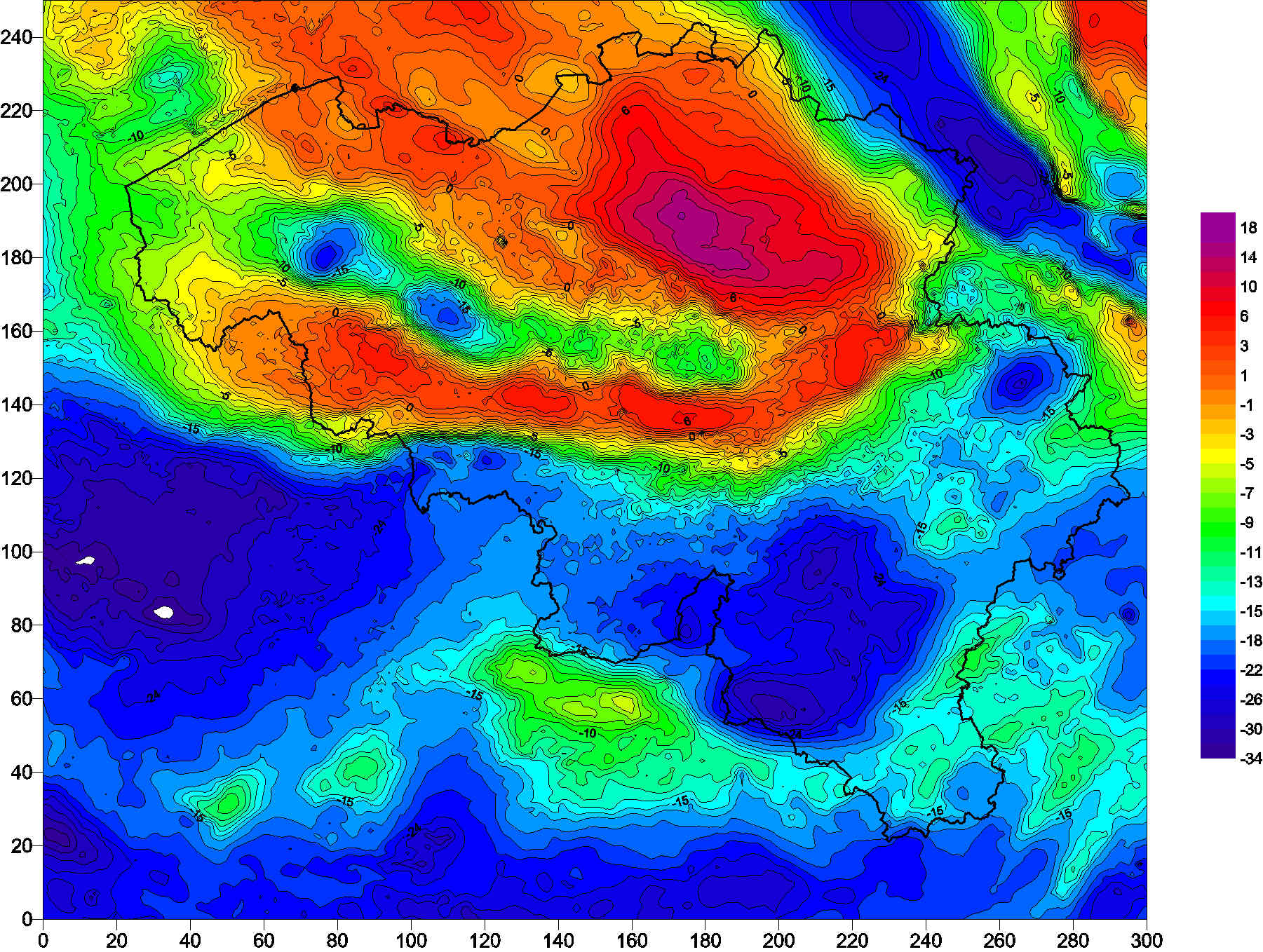
The Belgian gravimetric database consists of 69,000 measurements, made using relative spring gravimeters. This database is managed by the Royal Observatory of Belgium since 1925. Two superconducting gravimeters measure elusive gravity variations at the stations of Membach and Rochefort, with a precision better than 1E-10 of gravity at the surface of the Earth (g). Since 1996, an absolute gravimeter performs repeated gravity measurements at selected sites, with an accuracy of 1E-9 g.
-
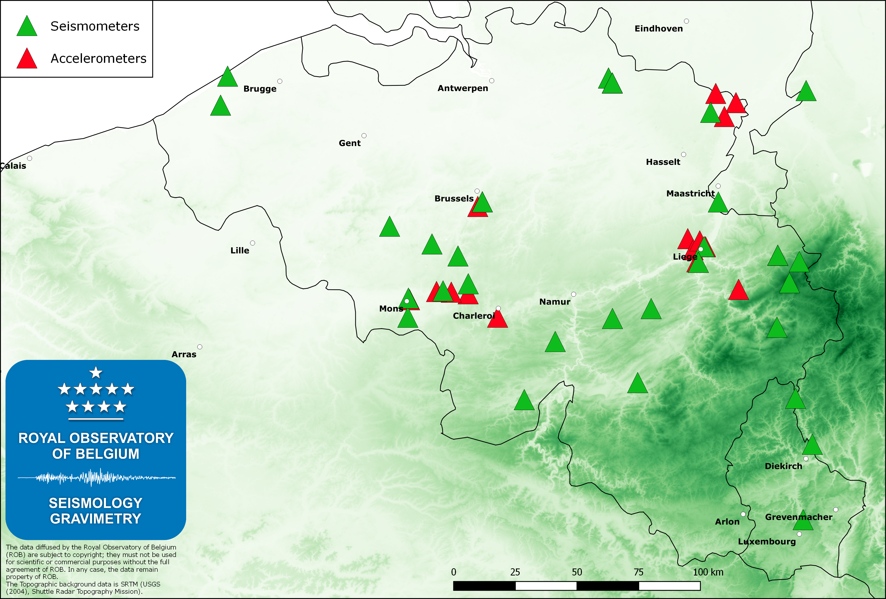
The Belgian seismic network of the Royal Observatory of Belgium (ROB), with about 45 permanent stations, is mainly dedicated to the monitoring and the scientific study of the seismic activity in Belgium. The ROB is also managing 3 stations in the Grand-Duchy of Luxemburg (in cooperation with the European Center for Geodynamics and Seismology). Earthquakes worldwide with magnitude greater than 4.5 – 5.0 are routinely recorded by the Belgian seismic network. The measurements on these recordings are sent to international seismological centers (EMSC and ISC) where data from stations worldwide are analyzed to furnish a global catalogue of earthquakes and phase arrival time models. We also provide real-time seismic signals from some Belgian stations to data exchange centers like ORFEUS (Observatories and Research Facilities for European Seismology) and IRIS (Incorporated Research Institutions for Seismology).To complement the seismic network, the Belgian accelerometric network was installed early in the 2000ies to furnish reliable data when strong ground motions saturate traditional seismometers. This network consists of 19 stations, is sensitive to accelerations of 1E-5 g (g is gravity at the Earth’s surface) and is an important tool for professionals in the field of earthquake engineering and engineering seismology (seismic hazard assessment). Currently, since 2014 the service is installing another network (“AcceleROB“) of 90 low-cost accelerometers. These sensors are calibrated to be sensitive to accelerations of 1E-3 g, which should be observed during any earthquake of local magnitude ML=3 or larger.
-

The data set has been established according to the INSPIRE format. It presents in the form of polygons the breakdown of Belgium in almost 20,000 statistical sectors. The statistical sector is the basic territorial unit resulting from the subdivision of the territory of municipalities by STATBEL since 1970 for the dissemination of its statistics at a finer level than the municipal level. A statistical sector cannot extend over two municipalities and any point in the municipal territory is part of one and the same statistical sector. The 1970 and 1981 versions are shown in analogue format while the 2001, 2011, 2018 and 2019 versions are available in digital vector format. The files can be linked to the data on population, housing and disposable income on the website of Statbel.
-
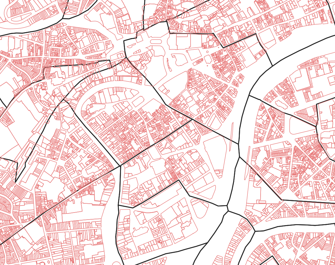
Mapping plan parcel - statistical sector corresponds to the dataset associating a plan parcel such as defined in article 2 of the Royal Decree of July 30th 2018 with the statistical sector including it. This dataset is composed of a single class mentioning the identifier of the plan parcels as well as the identifier of the statistical sectors. The dataset can be freely downloaded as a zipped CSV.
-
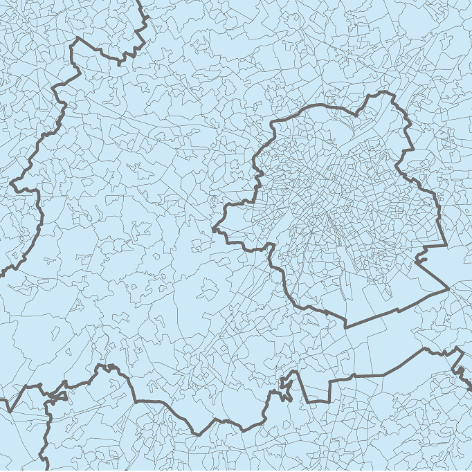
The data set includes three types of breakdown: Cities, Larger Urban zones or Functional Urban areas. BE_StatisticsBelgium_SH_SU_UA_CITY presents in the form of polygons the borders of the Belgian cities participating to the Urban Audit of the European Commission. Some cities consist in only one municipality (LAU2) while the others are the result of the aggregation of several municipalities (LAU2). Several versions of the breakdown (2001, 2002, 2010, 2019) follow one another because over the years new cities have taken part in it. The files can be linked to the statistical data collected for the Urban Audit. BE_StatisticsBelgium_SH_SU_UA_LUZ and BE_StatisticsBelgium_SH_SU_UA_FUA present in the form of polygons the areas of influence of the Urban Audit cities on the surrounding municipalities. The initial concept of Larger Urban Zones (LUZ) was replaced by the concept of Functional Urban areas (FUA) to take into account the movement of workers to the Urban Audit cities. LUZ / FUA are an aggregation of municipalities (LAU2). Several versions of the breakdown (2001, 2002, 2010, 2019) follow one another because over the years new LUZ / FUA have appeared or have seen their extension modified. The files can be linked to the statistical data collected for the Urban Audit.
-

This is the discovery service for the metadata which are made available by the Belgian federal government. It only contains the resources which have been declared for the INSPIRE reporting, i.e. the resources which contain the keyword “reporting INSPIRE”.